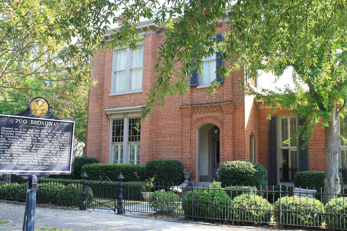
Columbus was conceived by the Georgia legislature in 1828 and became Georgia's first consolidated government in 1971. All 141 National Register sites.
Last checked Oct. 6, 2026. History facts come from the Columbus Consolidated Government’s 2025 annual comprehensive financial report. National Register listings come from the National Park Service’s National Register database, downloaded Oct. 6, 2026 (list dated May 22, 2026). Visitor details come from each site’s listing on Visit Columbus.
Columbus is a planned city. The Georgia legislature conceived it in 1828 as a trading town at the northernmost point of navigation on the Chattahoochee River, which forms the Georgia-Alabama line, according to the Columbus Consolidated Government. The city sits on the Fall Line, where the Piedmont meets the Coastal Plain, and the river’s falls powered the mills that made it a major industrial center in the 1800s. On Jan. 1, 1971, Columbus and Muscogee County became one government, the first consolidated city-county government in Georgia and the 17th in the nation.
Visit the history
- Historic Columbus Foundation: historiccolumbus.com
- Springer Opera House tours: 706-327-3688; box office 11 a.m. to 3 p.m. Monday to Friday
- National Civil War Naval Museum: 1002 Victory Drive, 706-327-9798
- Linwood Cemetery: 706-321-8285
- City planning, historic preservation: 706-225-3941
How Columbus became one government
The city’s annual financial report sets out the steps:
- Nov. 5, 1968: Georgia voters ratified a constitutional amendment allowing Muscogee County and the City of Columbus to consolidate.
- Nov. 3, 1970: voters ratified the charter drawn up by a commission the General Assembly created.
- Jan. 1, 1971: the consolidated government began, covering all 220 square miles of Muscogee County.
- 2001: Bibb City, a small textile town inside the county, gave up its charter, and the consolidated government took over its services. The General Assembly repealed the town’s charter on Jan. 31, 2001.
The historic districts
The Columbus Historic District, roughly between 4th and 9th streets, 4th Avenue and the river, was listed on the National Register on July 29, 1969, and enlarged in 1988, according to the National Park Service. Other listed districts include High Uptown (2004), Weracoba-St. Elmo (1994), Dinglewood (2001), Hillcrest-Wildwood Circle (2002), Peacock Woods-Dimon Circle (2003), Wynn’s Hill-Overlook-Oak Circle (2005), Wynnton Village (2005) and Bibb City (2010). Exterior changes in local historic districts go to the city’s Board of Historic and Architectural Review.
National Historic Landmarks
Three Columbus sites hold the nation’s highest historic designation, from the National Park Service’s records:
- Springer Opera House, listed on the National Register in 1970 and named a National Historic Landmark in 1978. Visit Columbus says it opened in 1871 and is the State Theatre of Georgia; docent-led tours are by appointment.
- Columbus Historic Riverfront Industrial District, listed and named a landmark in 1978.
- Octagon House, listed in 1969 and named a landmark in 1973.
Museums, cemeteries and places to visit
| Site | Address | Hours, as published |
|---|---|---|
| The Columbus Museum | 1251 Wynnton Road | 10 a.m. to 5 p.m. Tuesday to Saturday (to 8 p.m. Thursday); 1 to 5 p.m. Sunday |
| National Civil War Naval Museum at Port Columbus | 1002 Victory Drive | Call 706-327-9798 |
| National Infantry Museum and Soldier Center | 1775 Legacy Way | 9 a.m. to 5 p.m. Tuesday to Saturday; 11 a.m. to 5 p.m. Sunday |
| Historic Westville | 3557 South Lumpkin Road | 10 a.m. to 4 p.m. Friday and Saturday |
| Springer Opera House | 103 10th St. | Tours by appointment, 706-327-3688 |
| Linwood Cemetery | See Visit Columbus | Call 706-321-8285 |
Linwood Cemetery was established in 1828, four months before the city was founded, according to Visit Columbus. John Pemberton, the inventor of Coca-Cola, and Edwin Degraffinreid, who helped lay out the city, are buried there. The Naval Museum holds the CSS Jackson, which it describes as the largest surviving Confederate warship, and the wreckage of the CSS Chattahoochee.
Every National Register listing in Muscogee County
All 141 listings in the National Park Service’s database for Muscogee County, which is all of Columbus, with the year each was listed. Names are as the Park Service records them.
| Property | Address | Listed |
|---|---|---|
| 1238 Professional Building | 1238 2nd Ave. | 2022 |
| Adams Cotton Gin Building | 6601 Hamilton Rd. | 1984 |
| Berry, George O., House | 912 2nd Ave. | 1980 |
| Bibb City Historic District | Roughly bounded by Chattahoochee River, Woodland Cir., 2nd Ave. and 35th St., Bibb City | 2010 |
| Broad Street Methodist Episcopal Church South | 1323-1325 Broadway | 1980 |
| Building at 1007 Broadway | 1007 Broadway | 1980 |
| Building at 1009 Broadway | 1009 Broadway | 1980 |
| Building at 1400 Third Avenue | 1400 Third Ave. | 1980 |
| Building at 1519 3rd Avenue | 1519 3rd Ave. | 1980 |
| Building at 1531 3rd Avenue | 1531 3rd Ave. | 1980 |
| Building at 1612 3rd Avenue | 1612 3rd Ave. | 1980 |
| Building at 1617 Third Avenue | 1617 Third Ave. | 1980 |
| Building at 1619 Third Avenue | 1619 Third Ave. | 1980 |
| Building at 1625 Third Avenue | 1625 Third Ave. | 1980 |
| Building at 215 Ninth Street | 215 Ninth St. | 1980 |
| Building at 221 Ninth Street | 221 Ninth St. | 1980 |
| Building at 303 11th St. | 303 11th St. | 1980 |
| Building at 920 Ninth Avenue | 920 Ninth Ave. | 1980 |
| Building at 921 Fifth Avenue | 921 Fifth Ave. | 1980 |
| Building at 944 Second Avenue | 944 Second Ave. | 1980 |
| Bullard-Hart House | 1408 3rd Ave. | 1977 |
| Bush-Philips Hardware Co. | 1025 Broadway | 1980 |
| Butts, Thomas V., House | 1214 3rd Ave. | 1980 |
| C.S.S. MUSCOGEE AND CHATTAHOOCHEE (gunboats) | 4th St. W of U.S. 27 | 1970 |
| Cargill, Walter Hurt | 1415 3rd Ave. | 1980 |
| Carter and Bradley, Cotton Factors and Warehouseman | 1001-1037 Front Ave. | 1980 |
| Cedars, The | 2039 13th St. | 1971 |
| Central of Georgia Railroad Terminal | 1200 6th Ave. | 1980 |
| Central of Georgia Railroad Terminal | 700 12th St. | 1980 |
| Church of the Holy Family | 320 12th St. | 1980 |
| Church Square | Roughly bounded by 2nd and 3rd Aves., 11th and 12th Sts. | 1980 |
| City Fire Department | 1338 and 1340 Broadway | 1980 |
| Claflin School | 1532 5th Ave. | 2015 |
| Cole-Hatcher-Hampton Wholesale Grocers | 22 W. 10 St. | 1980 |
| Colored Cemetery | 10th Ave. | 1980 |
| Columbian Lodge No. 7 Free and Accepted Masons | 101 12th St. | 1980 |
| Columbus Coca-Cola Bottling Company | 1147 6th Ave. | 2022 |
| Columbus High School | 320 11th St. | 1980 |
| Columbus Historic District | Roughly bounded by 9th and 4th sts., 4th Ave., and the Chattahoochee River | 1969 |
| Columbus Historic District (Boundary Increase) | Bounded by Ninth and Fourth Sts., Chattahoochee River and Fourth Ave. | 1988 |
| Columbus Historic Riverfront Industrial District | Columbus River from 8th St. N. to 38th St. | 1978 |
| Columbus Investment Company Building | 21 12th St. | 1980 |
| Columbus Ironworks | 901 Front Ave. | 1969 |
| Columbus Manufacturing Company | 3201 1st Av. | 2007 |
| Columbus Stockade | 622 10th St. | 1980 |
| Cooke, Wm. L., House | 1523 3rd Ave. | 1980 |
| Denson, William H., House | 930 5th Ave. | 1980 |
| Depot Business Buildings | 519, 521 and 523 E. 12th St. | 1980 |
| Dinglewood | 1429 Dinglewood St. | 1972 |
| Dinglewood Historic District | Bounded by 13th and 16th Ave., 13th St., and Wynnton Rd. | 2001 |
| Dismukes, Robert E., Sr., House | 1617 Summit Dr. | 1979 |
| Elisha P. Dismukes House | 1515 3rd Ave. | 1980 |
| First African Baptist Church | 901 5th Ave. | 1980 |
| First African Baptist Church Parsonage | 911 5th Ave. | 1980 |
| First National Bank | 1048 Broadway | 1974 |
| First Presbyterian Church | 1100 1st Ave. | 1980 |
| Fletcher, John T., House | 311 11th St. | 1980 |
| Fontaine Building | 13 W. 11th St. | 1980 |
| Fortson House | 1100 Fortson Rd., Fortson | 1999 |
| Frank Brothers | 18 W. 10th St. | 1980 |
| Gann’s Pharmacy | 1611 2nd Ave. | 1980 |
| Garrett-Bullock House | 1402 2nd Ave. | 1980 |
| Girard Colored Mission | 1002 6th Ave. | 1980 |
| Goetchius-Wellborn House | 405 Broadway | 1969 |
| Golden Brothers, Founders and Machinsts | 600 12th St. | 1980 |
| Green Island Ranch | 6551 Green Island Dr. | 1997 |
| Harrison-Gibson House | 309 11th St. | 1980 |
| High Uptown Historic District | Roughly bounded by 2nd and 3rd Aves. between Railroad and 13th Sts. | 2004 |
| Highland Hall | 1504 17th St. | 1980 |
| Hillcrest-Wildwood Circle Historic District | Roughly bounded by Wildwood Ave., 13th and 17th Sts., and Dixon Dr. | 2002 |
| Hilton | 2505 Macon Rd. | 1972 |
| Hofflin & Greentree Building | 1128-1130 Broadway | 1982 |
| Illges House | 1428 2nd Ave. | 1973 |
| Illges, John Paul, House | 1425 3rd Ave. | 1980 |
| Isaac Maund House | 1608 3rd Ave. | 1980 |
| Joseph House | 828 Broadway | 1969 |
| Kress | 1117 Broadway | 1980 |
| Lafkowitz, Abraham, House | 934 5th Ave. | 1980 |
| Ledger-Enquirer Building | 17 W. 12th St. | 1980 |
| Lewis-Rothchild Building | 1214 First Ave. | 2004 |
| Liberty Theater | 821 8th Ave. | 1984 |
| Lion House | 1316 3rd Ave. | 1972 |
| Loeb, Sol, Building-Garrett-Joy Building | 900 Front Ave. and 901 Broadway | 2005 |
| McArdle House | 927 3rd Ave. | 1980 |
| McGehee-Woodall House | 1534 2nd Ave. | 1972 |
| Methodist Tabernacle | 1605 3rd Ave. | 1980 |
| Mott House | Front Ave. | 1974 |
| Mott-Fox-Hugley House | 2027 6th Ave. | 2012 |
| Octagon House | 527 1st Ave. | 1969 |
| Old City Cemetery | Linwood Blvd. | 1980 |
| Old Dawson Place | 1420 Wynnton Rd. | 1979 |
| Peabody-Warner House | 1445 2nd Ave. | 1970 |
| Peacock Woods-Dimon Circle Historic District | Bounded by Cherokee and Forest Aves. and 13th and 17 Sts. | 2003 |
| Pemberton House | 11 7th St. | 1971 |
| Phillips, George, House | 1406 3rd Ave. | 1980 |
| Pond, George, House | 922 2nd Ave. | 1980 |
| Power and Baird, Wholesale Dry Goods and Notions | 1107 Broadway | 1980 |
| Rainey, Gertrude Ma Pridgett, House | 805 5th Ave. | 1992 |
| Ralston Hotel | 211 12th Street | 2025 |
| Rankin House | 1440 2nd Ave. | 1972 |
| Rankin Square | Bounded by Broadway, 1st Ave., 10th and 11th Sts. | 1977 |
| Reich Dry Goods Company | 14 W 11th St. | 2004 |
| Ridgewood | Jenkins Rd., Upatoi | 1980 |
| Roberts, John Spencer, House | 927 5th Ave. | 1980 |
| Rose Hill School | 433 21st St | 2022 |
| Rosenberg, Max, House | 1011 3rd Ave. | 1980 |
| Rothschild’s, David, Wholesale Dry Goods | 1029 Broadway | 1980 |
| Rothschild, David, House | 1220 3rd Ave. | 1980 |
| Secondary Industrial School | 1112 29th St. | 1980 |
| Silver’s Five and Dime Store-H.L. Green Co. | 1101-1103 Broadway | 2005 |
| Sixteenth Street School | 1532 3rd Ave. | 1980 |
| Southern Railway Freight Depot | 1300 6th Ave. | 1997 |
| Spencer, William Henry, House | 745 4th Ave. | 1978 |
| Springer Opera House | 105 10th St. | 1970 |
| St. Christoper’s Normal and Industrial Parish School | 900 5th Ave. | 1980 |
| St. Elmo | 2810 St. Elmo Dr. | 1971 |
| St. John Chapel | 1516 5th Ave. | 1980 |
| Swift Manufacturing Company | 1410 6th Ave. | 2014 |
| Swift-Kyle House | 303 12th St. | 1973 |
| Tarver, C.B., Building | 18-23 W. 11th St. | 2005 |
| Thomas, Alma, House | 411 21st St. | 2009 |
| Triangle Building | 1330 Broadway | 1980 |
| Trinity Episcopal Church | 1130 1st Ave. | 1980 |
| Turner, Charles E., House | 909 3rd Ave. | 1980 |
| U.S. Post Office and Courthouse | 120 12th St. | 1980 |
| W. Jacob Burrus House | 307 11th St. | 1980 |
| Walker-Peters-Langdon House | 716 Broadway | 1969 |
| Waverly Terrace | Roughly bounded by Hamilton Rd., Peabody Ave., 27th and 30th Sts. | 1983 |
| Wells-Bagley House | 22 6th St. | 1969 |
| Weracoba-St. Elmo Historic District | Roughly bounded by 13th and Virginia Sts., 13th, 15th, 16th and Cherokee Aves. and Talbotton Rd. | 1994 |
| Wolfson Printing and Paper Co. | 24 W. 10th St. | 1980 |
| Woodruff, Ernest, House | 1414 2nd Ave. | 1980 |
| Woodruff, Henry Lindsay, House | 1535 3rd Ave. | 1980 |
| Woodruff, Henry Lindsay, Second House | 1420 2nd Ave. | 1980 |
| Woolfolk, John W., House | 1615 12th St. | 1979 |
| Wynn House | 1240 Wynnton Rd. | 1972 |
| Wynn’s Hill-Overlook-Oak Circle Historic District | Roughly bounded by Bradley Rd., Buena Vista Rd., Overlook Ave., Crest Dr., and Oakview Ave. | 2005 |
| Wynnton Academy | 2303 Wynnton Rd. | 1972 |
| Wynnton Village Historic District | Roughly bounded by Wildwood Ave., Forest Ave., 18th St., 13th St., 16th ave. Wynnton Rd. | 2005 |
| Wynnwood | 1846 Buena Vista Rd. | 1972 |
| Y.M.C.A. | 124 11th St. | 1980 |
What this means for you
- Start downtown: the Columbus Historic District, the Springer Opera House and the riverfront industrial district are all in or near Uptown.
- Own a building in a local historic district? Check with the Planning Department’s historic preservation planner, 706-225-3941, before exterior work.
Related: Columbus population, Uptown Columbus and free things to do.
Frequently asked questions
When was Columbus, Georgia, founded?
The Georgia legislature conceived Columbus in 1828 as a planned town at the northernmost point of navigation on the Chattahoochee River, according to the Columbus Consolidated Government.
When did Columbus and Muscogee County consolidate?
On Jan. 1, 1971. Voters ratified the consolidation charter on Nov. 3, 1970, and Columbus became the first consolidated city-county government in Georgia and the 17th in the nation.
How many National Register of Historic Places listings are in Columbus, Georgia?
The National Park Service lists 141 National Register properties and districts in Muscogee County, including three National Historic Landmarks: the Springer Opera House, the Octagon House and the Columbus Historic Riverfront Industrial District.
What is the oldest cemetery in Columbus, Georgia?
Linwood Cemetery, established in 1828, four months before Columbus was founded, according to Visit Columbus. Coca-Cola inventor John Pemberton is buried there. Phone: 706-321-8285.
Have your say